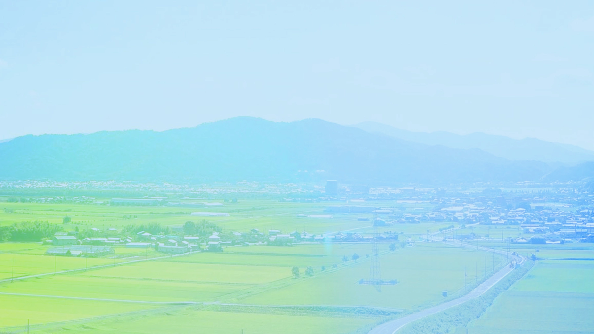

In response to the global climate change, the "Kameoka City Watershed Space Design Conference" presented a proposal titled "Living with Water and Greenery - Recommendations for the Era of Watershed Management in Kameoka City" in May, 2023. Based on this proposal, efforts to concretely examine urban development in the era of watershed management are being sought. Within this context, this international students' workshop is conducted, taking into account interviews with citizens and on-site observations, to facilitate the exchange of ideas about the direction of urban/rural development in Kameoka City during the watershed era.
Participant
-
Host Universities
Chiba University, Kyoto University, Ritsumeikan University
-
Guest Universities
Delft University of Technology, University of Tsukuba, Kyoto University of Advanced Science
Hosted by
-
the Watershed Spatial Design Research Group(Chiba University - Shiro Takeda Lab., Kyoto University - Keita Yamaguchi Lab., Ritsumeikan University - Masakazu Hanaoka Lab. and Toshihiko Abe Lab.)
Cooperation from
-
Fogin General Incorporated Association, Delft University of Technology -Steffen Nijhuis Lab. (Netherlands), Ritsumeikan University Institute for Disaster Mitigation of Urban Cultural Heritage, University of Tsukuba - Keisuke Sugano Lab., Kyoto University of Advanced Science - Hidenori Niwa Lab.
Supported by
-
Kameoka City
Grants
-
Grant-in-Aid for Scientific Research (B) Methodological development of “watershed spatial design” that adapts to climate change (Research project number: 23H03674, Representative: Shiro Takeda)
Updates
Schedule
Day1
- TIME
-
- Assembly and Orientation
- Introduction, Member Introductions, Overview Explanation
- Presentation of Pre-Research Findings
- Presentation of "Eight Missions"
- TIME
-
- Visit to Sogagawagawa and Hosugawa Riverside Park
- TIME
-
- Lunch
- TIME
-
- Visit to Yawaragi-no-Michi and Shichitani River
- TIME
-
- Visit to Kawahayashi Village
- TIME
-
- Experience Traditional Japanese Confectionery Making
- TIME
-
- Dismissal
- Participants to have dinner and engage in social interactions at their accommodations, such as farmhouse lodges
Day2
- TIME
-
- Assembly and Orientation
- TIME
-
- Tour of Mountain Forest Tourism
- TIME
-
- Visit to Lifelong Learning Centers, Roadside Stations, and Childcare Facilities
- TIME
-
- Visiting an old agricultural reservoir incorporated into the urban area.
- TIME
-
- Visit to Nango Park and Kameyama Castle Ruins
- TIME
-
- Lunch
- TIME
-
- Presentations of the Groups for Missions Investigation
- TIME
-
- Dismissal, Group Work
Day3
- TIME
-
- Assembly and Orientation
- TIME
-
- Group Work
- TIME
-
- Lunch (Bento)
- TIME
-
- Group Work
- TIME
-
- Intermediate Presentation
- TIME
-
- Group Work (if necessary)
Day4
- TIME
-
- Assembly and Orientation
- TIME
-
- Group Work
- TIME
-
- Lunch (Bento)
- TIME
-
- Final Presentation
Presentation of the achievements by each group regarding the "Eight Missions"
- Final Presentation
- TIME
-
- Farewell Party
- TIME
-
- Dismissal

Links for the references
- 水とみどりと暮らす 〜亀岡市における流域治水時代のまちづくりに向けた提言〜
- 水とともに暮らす亀岡2070 〜U40が亀岡の未来について語るワークショップ〜
- 亀岡まるごとガーデンミュージアム構想
- 流域治水の推進 ~これからは流域のみんなで~(国交省HP)
- 武田・山口・花岡・並河・他(2023)亀岡市における流域空間デザイン検討会議とその提言について:歴史都市防災論文集 17,p.231-236.
8missions
We would like you to propose a pilot project, or initiatives that would be beneficial, including in the future.
MISSION
Kyoto-Kameoka Hosozugawa Park Area
- Theme
- The park that coexists with the environment, with systems to utilize local resources in a sustainable way
- Hints
- Ayumodoki, agriculture, use of locally produced wood, environmental tax, OECM
- Assignment
-
Kyoto's Kameoka Hozugawa Park was the land that was initially planned as the construction site for Kyoto Stadium, but it was deemed unsuitable as a construction site because of the presence of the rare fish species called Ayumodoki along the Sogatani River. After that, the city planning decision was made to use the site as a site for the development of a city park.
There is an open part of the levee at the eastern end of the planned site at the point just before the Sogatani River joins the Hozu River (Oi River), which is why the land floods when the river rises.
Currently, the design of the park is being considered in a way that preserves some of the paddy fields while incorporating them into the park and conserving the habitat of Ayumodoki.
The planning and operation of this park, with above mentioned conditions, will serve as a touchstone in Kameoka City's urban development in the era of watershed flood control, embodying the future vision of Kameoka that lives with water and greenery.
On the other hand, as is well known, basin flood control is a concept that can only be established by considering every section of the land from mountains to rivers as one continuum, and cannot be achieved simply by having parks catch excessive water. Parks that frequently flood would require more maintenance and management costs than regular parks, and therefore, improving water retention capacity of forests upstream through sound management to decrease water runoff will then be another important issue.
In order for this park to truly become a symbol of urban development in the era of watershed flood control, it is necessary to develop a completely new park plan and use methods that take into account management at the basinwide scale, a system for maintenance and management, and a funding cycle to support it. The park needs to embody the system.
What kind of design makes this possible? Suggestions from both hardware and software perspectives are expected.
MISSION
Former Heiwa Pond Area
- Theme
- Ecosystem Conservation and Rainwater Storage
- Hints
- OECM Regulation Reservoir, Financial Institution Investment, Green Bonds
- Assignment
-
The Former Heiwa Pond (“Peace Pond”) area is located in the southern part of Kameoka City. Former Heiwa Pond was once used as a dam, but in 1951 it collapsed due to the flood, causing severe damage to the downstream area.
This area is currently adjacent to a residential area called Minami Tsutsujigaoka Sakuradai, which is popular as a commuter town, but access to the Heiwa Pond site is not necessarily good. Efforts are being made around the Heiwa Pond ruins to preserve the memory of the flood event, but the actual land remains virtually untouched.
Rich in natural resources, with water, forests, and a thriving ecosystem, it has been designated as an important satoyama by the Ministry of the Environment. There are plans to develop this area as a “Heiwa-no-Mori (Peace Forest) Natural Park,” but to date no use has been made of the site, including park development.
On the other hand, according to the concept of EcoDRR (Ecosystem-based Disaster Risk Reduction), in order to develop a city in the era of basinwide flood control, land management aimed at both ecosystem conservation and rainwater storage while taking advantage of the natural environment is important.
Naturally, such management requires a certain amount of cost, so some kind of system to support it and ideas for effectively utilizing the natural environment itself.
In order to answer these issues, in addition to using the park as a premise, we also aim to contribute to local disaster mitigation and wide-area (regional?) flood control in order to realize the international goal of 30 by 30. By publicizing the area as a region that contributes to the development of local communities, there is a possibility of not only gaining support from the regional government, but also attracting domestic and foreign investment.
What kind of comprehensive proposals can be made to realize this direction? Suggestions from both tangible and intangible perspectives are expected.
MISSION
From Station South Exit to Nango Park Area
- Theme
- Urban Regeneration through Green Infrastructure
- Hints
- Rain Gardens, Small Residential Lots, Aging Population, Creating New Attractions
- Assignment
-
The area from the south exit of JR Kameoka Station to Nango Park is currently densely urbanized. However, the original urban core of Kameoka was the castle town around Kameyama Castle, and until the 1920s, the station located in the lower land was surrounded by rice paddies with a narrow road leading to the station. Even in the 1960s, only along that street in front of the station were ocupied with buildings. It is only after the 1970s that the area south of the station, where the land has been raised, has been developed. In more recent years, Kyoto Stadium has been built on the north side of the station, with the surrounding land also being developed, and there has been discussion about whether such development would damage the long-term safety and the unique landscape of Kameoka, which has been developed in deep relation with water.
On the other hand, the area around the current south exit of the station, despite the existence of the historical areas such as Kameyama Castle, Nango Park, and the castle town as its backdrop, does not seem attractive enough or functional to meet its location as the gateway for the visitors from outside the city. Although there are some stores, there are also many small residential lots that are not well utilized, and the aging population of the area is also an issue.
Now that we are facing climate change and advocating urban development in the era of basinwide flood control, what kind of form should the south exit area of Kameoka Station aim for in the future?
There must be various approaches to urban regeneration in the area, but the mission given in this workshop will be to explore measures to make the most of green infrastructure ideas and create new urban appeal that contributes to regional safety as well. Please make bold proposals from both aspects of tangible and intangible.
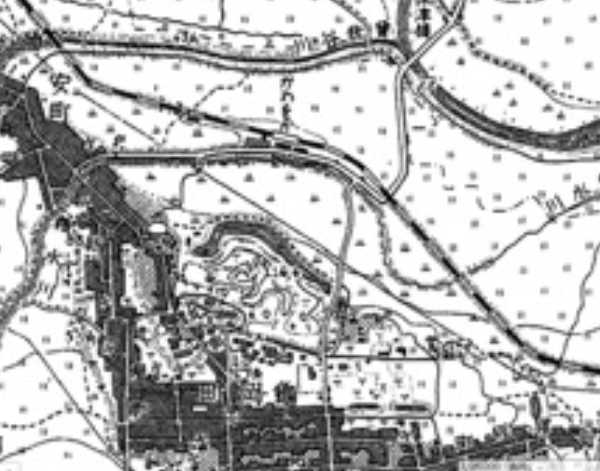
1920s 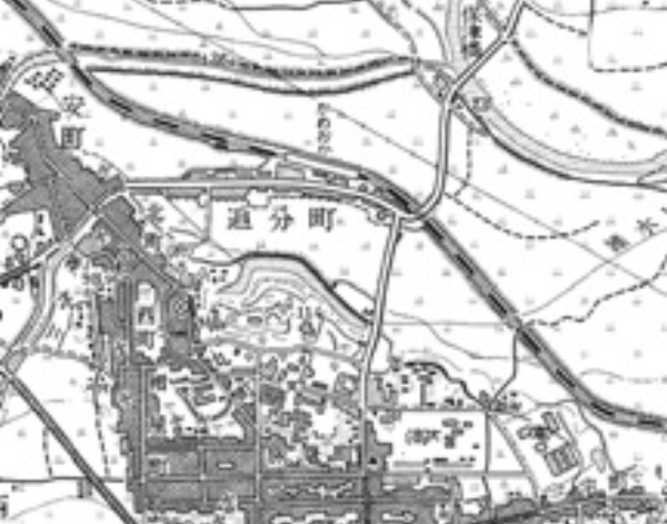
1960s
MISSION
Yasumachi Great Pond Area
- Theme
- Conversion of Reservoirs into Regulated Green Spaces
- Hints
- Transformation of Agricultural Infrastructure into Green Infrastructure, Park Greening
- Assignment
-
Yasumachi Oike Pond was once used as a water source for agricultural purposes, but has now lost most of its functions, mainly due to the urbanization of surrounding farmland since the 1970s. There are also requests from the local community to turn it into a park. In the era of river basinwide flood control, the many reservoirs at the foot of mountains can be expected to function as regulating reservoirs, depending on how they are used.
Since the city hall is nearby, it may be possible to expect the site to be a new base for some new service for citizens. If we take into consideration the entire area leading to the former kindergarten site and open spaces in more southern areas such as around the Furu Ike (Old Pond) where the current crematorium is located, we can see that all that area may even be considered as a continuous and accesible green area in a larger scale along the eastern edge of the mountain. (As for the current crematorium, a basic plan for relocating it to another site was drawn up in 2019.)
Nevertheless, since reservoirs were not originally designed as park aquascapes or regulation ponds, there are various issues that must be resolved in order to operate them for safety and flood control purposes. In addition, even if a green space is planned for the purpose of flood control, implementation cannot be expected unless there is a clear outlook on the entity responsible for the enterprise and financial support that will be required not only for construction but also for a longterm maintenance and management.
Based on these opportunities and constraints, proposals of a new green infrastructure system and its spatial vision considered both from tangible and intangible perspectives are expected.
MISSION
From Kawarabayashi-cho to Hozu-cho Area
- Theme
- Rice Field Dams, History + Green Tourism
- Assignment
-
The downstream area of the Hozu River has had a high risk of flooding for a long time, and its use for other use than rice fields has been restricted. However, partly as a result of that, the Kawarabayashi-Hozu-cho area has a vast and beautiful rural landscape. The area is dominated by rice paddies and is known as one of Kameoka City's leading granary areas. The old San'in Road passes through the village along the edge of the mountain. The village has not only historic buildings, but also the traditional customs and cultures that have been passed down since ancient times. Stone walls and hedges that were created as historical flood countermeasures can be seen within the village, creating a unique landscape of the area. There is a road called Yawaragi no Michi around Kawarabayashi-cho, which is also used for sightseeing. However, other areas are not used for tourism despite the beautiful scenery, and the riverbanks along the villages have not been developed to be used as aquatic spaces.
From the perspective of basinwide flood control, areas with many rice paddies like this area are usually regarded to be a treasure trove of potential “rice paddy dams”. However, in order to realize such ideas, a certain amount of burden would be placed on local residents not only in its maintenance but also in its operation. Additionally, rice field dams are only effective if they are implemented over a wide area. If we were to achieve more intensive rainwater storage instead, it may probably be necessary to accept the sacrifice of productivity in some rice paddies.In order to ensure that these measures do not simply restrict land use and sacrifice productivity in the area, it is necessary to come up with effective design approaches. For example, we may want to take advantage of such flood control measures to promote green tourism that makes use of the region's history and natural environment. With careful planning, it may also be possible to increase the depth of green tourism by promoting opportunities for outdoor activities in Kameoka City even further.
Please propose an initiative from both tangible and intangible perspectives that will utilize the basinwide flood control measures in the area as a tourism resource and balance the local economy and the environment and its safety.
- Refference
-
- 焦 英楠・他(2022):グリーン・ブルースポットを用いた流域全体での洪水調節機能評価 : 京都府亀岡市の支流域をケースとした試行的解析:歴史都市防災論文集,16, p.41-48
- 焦 英楠・他(2023):グリーン・ブルースポット解析に基づく亀岡市川東地区における流域空間デザインの試行的計画:歴史都市防災論文集,17,p.237-244
MISSION
Mountainous Area of the Atago-valley River Area
- Theme
- Resource Utilization and Improvement of Mountain Forests, Creating a Community of Stakeholders, Environmental Tax
- Hints
- Theme-based Community through Projects like Mountain Biking, Tent Saunas, etc.
- Assignment
-
Basinwide flood control can be regarded as the creation and maintenance of a certain environment where people can live with safety and wellbeing through the integrated management of continuum of land from mountains to rivers. Healthy forests can retain a large amount of water, which reduces flood risk downstream and recharges aquifers and other water sources that support a rich natural environment. However, due to the severity of heavy rains in recent years, many areas of this country have been suffering from fallen trees due to typhoons, and the mountains of Kameoka are no exception. It may be difficult to find fundamental solutions in our short workshop to such major challenges. It can fairly be said that in the background of this situation, there are the structural changes in industry, distribution, and energy supply overtime, which led to the decline of the relationship with mountains and the interest in them in our everyday lives. Consequently, the investment in forest management has decreased dramatically. Even under these circumstances, there are also notable trials starting such as the town of Kamikawa in Hokkaido to prepare mountain bike courses to foster citizen use and interest in mountain forests, and “Kameoka Satoyama Sauna Construction Project” that has raised its fund through crowdfunding.
In this mission, we would like you to focus on the Atago Tanigawa Forest Area as a hypothetical site for a pilot project of urban/rural development in the age of basinwide flood control. In the upstream (of this area), flood mitigation measures are considered in the area around the reservoir, yet the forest which was damaged by the typhoon still needs time to recover.
Through this case study, it is hoped to foster a new theme-based community that takes advantage of the mountain and forest environment, and make unique proposals that will serve as a catalyst for a new sustainable relationship among forest, river and town.
Small Watershed Planning Type
As a brainstorming session for the Watershed Town Planning Vision, we propose planning at the small watershed scale based on two small rivers.
MISSION
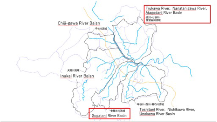
Nanatani River Watershed
- Keywords
- Rice Field Dams, Reservoirs, Rural Tourism, Ceiling Rivers, Utilization of Mountain Forest Management, Others
- Assignment
-
When considering flood control in a watershed, it is necessary to think in terms of tributary watersheds. The towns of Hozu and Kawarabayashi in the east of the river which are downstream areas of the Nanatani River watershed and called Kawahigashi, have long suffered from frequent flooding damage, and in 2004,they were inundated by Typhoon No. 23. On the other hand, vast areas of rice paddies and other agricultural lands are located in the Nanatani River basin, and have the potential to store water through rice paddy dams(田んぼダム) and other means. In addition, the Kawahigashi area has flourished as an important transportation hub since ancient times, and the foothills and micro-elevations of Hozu-cho and Kawarabayashi-cho are dotted with historical sites such as the Tamba Kokubunji and Tamba Kokubunniji temple sites, Izumo Grand Shrine and other shrines and temples, and villages. Agriculture is also flourishing, and the management and utilization of Kawahigashi's mountainous terrain is an important issue. It is expected to create a region of cultural experiences and exchanges by utilizing these cultural heritages, agricultural lands, and mountain forests.
Hiranosawaike Pond, which was developed as a reservoir for agriculture, is a place where wild birds can be seen throughout the year, especially from fall to spring when many species and numbers of ducks migrate to the area. Nakaike Pond is also one of the few places in Japan where onibasu (Oncorhynchus masou) grow naturally, and the lower reaches of the Nanatani River are expected to become a habitat for rare species from the perspective of ecosystem conservation, including the need to take care of the ayumodoki, which is a protected species.
The entire watershed should be considered to prevent flood damage in the downstream areas, improve the environmental value of the entire watershed including the ecosystem, and revitalize local communities by utilizing local historical and natural resources. Please propose specific ideas on the direction of such community development from both tangible and intangible perspectives.
MISSION
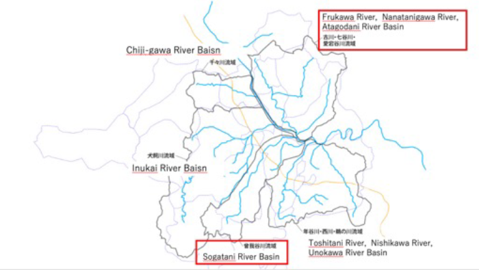
Sogatani River Watershed
- Keywords
- Kyoto-Hosozawa Riverside Park, Ayumodoki, Small Tributary Play Ponds, Rice Field Dams, Others
- Assignment
-
The Sogatani River watershed has frequently been flooded, especially at the confluence with the Katsura River, downstream areas, and along the old river. Urban areas are spreading downstream and along the former river site, and it is expected that water will be stored upstream to mitigate the damage. In addition, the Galleria and Kyoto Kameoka Campus of Kyoto University of Advanced Science are located along the river, and agricultural lands are spreading. Flood control and community development in the watershed are expected to take advantage of these existing and new facilities.
In addition, the downstream portion of the Sogatani River and the confluence of the Katsura River is a habitat for the ayumodoki, which is a protected species, and special consideration must be given.
The entire basin as a whole must be considered to prevent flood damage in the downstream areas, improve the environmental value of the entire basin including the ecosystem, and revitalize local communities by making the most of local resources. Please provide specific proposals on the direction of such community development from both tangible and intangible perspectives.
- Refference
-
- 水とみどりと暮らす 〜亀岡市における流域治水時代のまちづくりに向けた提言〜
- 水とともに暮らす亀岡2070 〜U40が亀岡の未来について語るワークショップ〜
- 亀岡まるごとガーデンミュージアム構想
- 流域治水の推進 ~これからは流域のみんなで~(国交省HP)
- 武田・山口・花岡・並河・他(2023)亀岡市における流域空間デザイン検討会議とその提言について:歴史都市防災論文集 17,p.231-236.